Weather Forecast: http://tinyurl.com/ElenaGallegosWeather
Fire Restrictions: http://firerestrictions.us/nm/nm-usfs/cibola-nf--sandia-district/
The trail leading from Elena Gallegos Picnic Area up through Domingo Baca Canyon is the first backpacking trip I ever took my scouts on, and it is a continual favorite. It's close, it's pretty, and it is always cooler up there than here in town. Even though you start out in high desert terrain, you are up in green forested regions of the Sandias before the end of this moderate 2-mile hike, entertained by the sounds of a year-round stream running right by the campground (35.1813667°, -106.4573667°).
Well, there is no established campground, but there is only one good location that will accommodate more than 5 people once you get into the mountains. So, if you go in the summer and don't arrive early enough, you may find it occupied. The first time we went, we headed up around 4:30pm and within 10-20 minutes of arriving at the camp site at least 2 other groups had hiked by, apparently hoping to camp in the spot we had snatched.
The hike to the campsite location is of easy-to-moderate difficulty. It's not dead flat like San Lorenzo Canyon, but will likely only be somewhat challenging to the most novice beginner. Over the 2 miles, you'll only cover about 700 ft in elevation, so it's not bad. Most of that is in the last mile or so. At the bottom of this blog post is the elevation profile for the hike.
 |
| High Desert Terrain for the first mile of the hike |
 |
| Lush surroundings as you get further into the canyon |

 |
| Nice campsite near the stream about 2 miles in |
However, you don't have to stop at the campsite. Another 2 miles past the campsite, there is a wonderful bit of history and physical challenge in the hike up to the site of a 1955 TWA plane crash. See more info here. The lush and rugged terrain will open up to even more beautiful vistas high in the Sandias. This trail will take you directly under the path of the Tram, which at places will be only a few hundred feet above you.
 |
| If you continue the hike to the TWA crash site, you will come very near the top of the Sandias |
 |
| Memorial when the trail gets to the beginning of the wreckage for the TWA crash site |
Note that while the hike to the campsite is fairly straightforward and of only moderate difficulty (with a backpack), the hike to the crash site could be considered difficult. In the 2 miles to the beginning of the crash site (the debris is strewn across a few hundred yards of a very narrow canyon high in the Sandias), you will climb another 1500 feet in elevation, and the trail is pretty primitive. It is a little hard to follow at times, but once you get much past the campsite, pretty much any trail you find will lead to the crash site. Still, I recommend a GPS (with map and compass as backup). There are one or two places where you will have to scramble up rocks and boulders. It's not really that hard; I see senior citizens do it all the time (in better time than I do), but it isn't a walk in the park. The payoff is awesome.
Another alternative: Soon after you pass the campsite mentioned above, the trail initially continues to follow the stream for a while, but soon diverges. It will meet up with the stream again occasionally afterwards. However, if you keep to the stream from the point you leave the campsite, you will come to a small waterfall in the stream after a little while (a few hundred yards; maybe half a mile?... It's been a while, and I can't remember). The fun part is that in the winter, this will often be frozen over. So, that makes a fun destination for a winter day hike. Note - depending on how much snow cover there is, the stream can be very hard to follow off trail, but you'll get there eventually. And, if you do choose to leave the trail, please tread lightly.
 |
| Frozen waterfall up Domingo Baca Canyon |
The chart shows the elevation profile starting at Elena Gallegos all the way to the top at the crash site. The blip just past the two mile mark is where we camped, I believe; I think the discontinuity is just due to the calibration difference between when I turned off the GPS at night, and when I turned it on the next morning, before I had moved around enough for it to get its proper bearings.
 |
| GPS Elevation Profile of Hike from Trailhead to Crash Site |
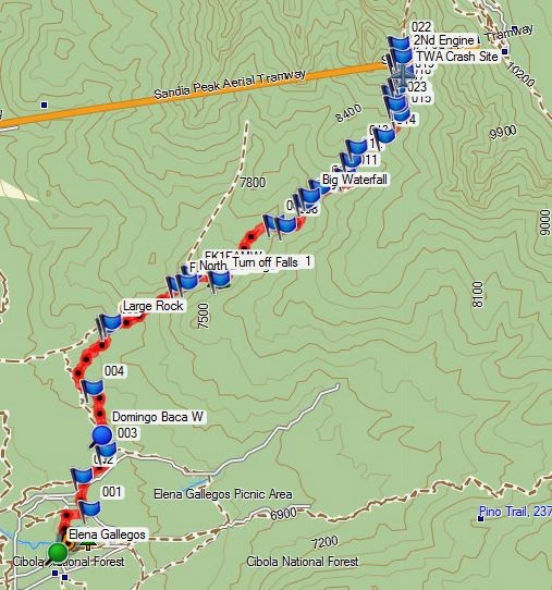
The map below is a representation of my GPS tracklog. You can download the *.gpx file from that link, if you'd like. There are LOTS of trails in the Elena Gallegos area, so it isn't really as simple as following a single trail up. Once you get turn into the mountains, it all leads to the same area, but even then, there are a few wrong turns you can make.
BTW - I took my pre-teen daughter on a daddy-daughter backpacking trip up this trail to the campsite I mentioned in the post, then did a few day hikes around the area, including the waterfall. It was great! What a wonderful time!
ReplyDelete